If AI Takes Over Mapping, What Is Left for Humans? 当AI接管制图,人类是否应该退场?
From mapping to GIS and GeoAI, many cartographic abilities are being taken up by technology. The more capable the tools become, the more clearly human judgment matters. 从制图到 GIS,再到 GeoAI,许多和制图直接相关的能力正在被各类新兴技术接管。技术越能干,人的判断越重要。
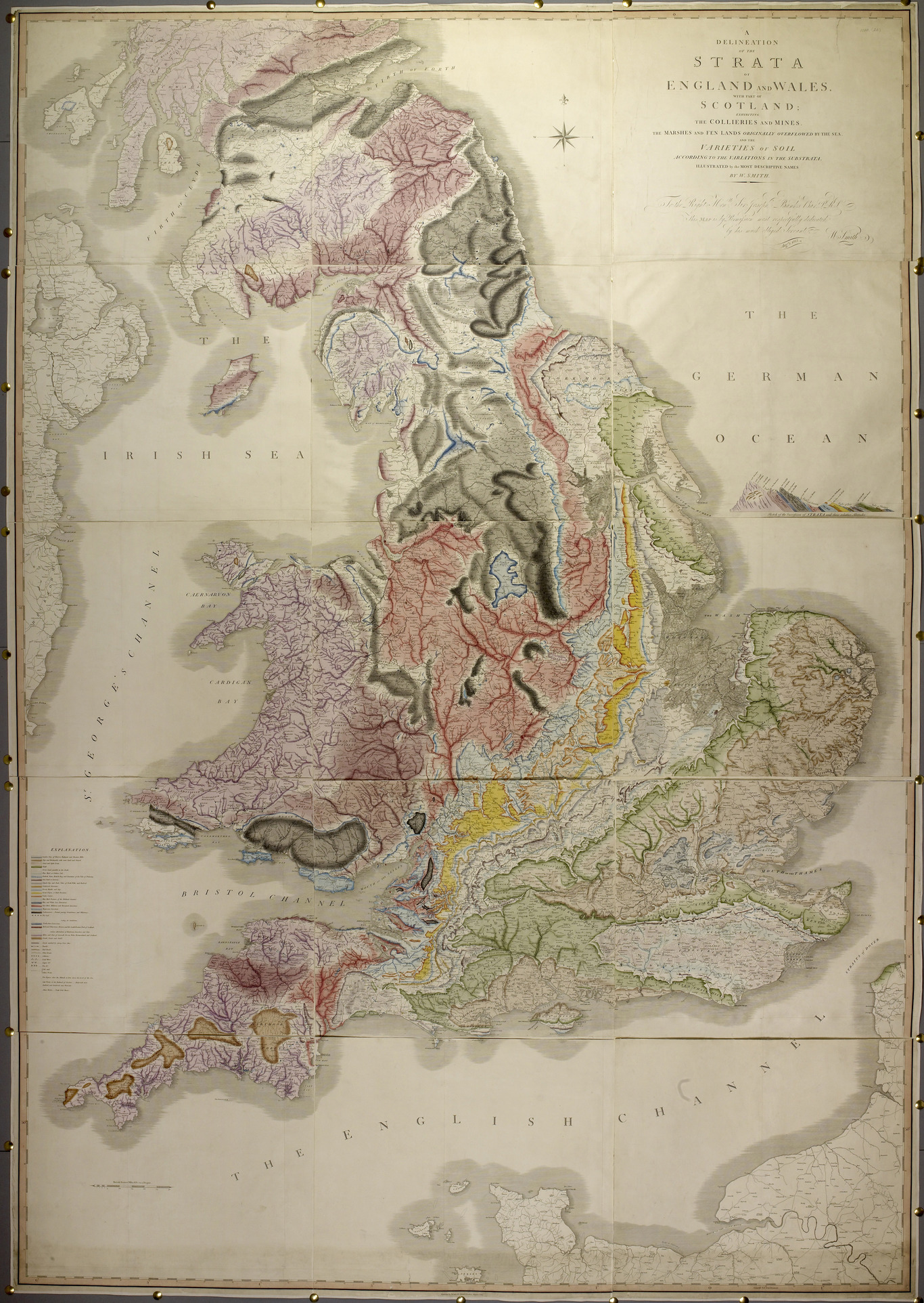
At first, William Smith's 1815 geological map appears as an old object of beauty. Britain lies on the page in muted greens, browns, yellows, reds, and grays. The coast is familiar, but the land has been opened from within. Color follows strata instead of political borders. Lines do not merely outline territory; they suggest time, pressure, depth, and memory. The map seems quiet, but it is making an argument before we have even begun to read it.
To make such a map, one needed more than a hand that could draw. One needed memory: of roads and canals, of quarries and cliffs, of fossils held in the palm, of workers' accounts, of local names, of what one stratum looked like when it disappeared under another. The mapmaker had to remember how a landscape changed from county to county and how a color on paper could stand for something hidden under soil and stone. Mapping was never only handwork. It was a trained relationship among eye, instrument, walking, memory, and judgment.
Within GIScience, Daniel Z. Sui and Michael F. Goodchild made this question explicit when they asked whether GIS were becoming media. Their argument brought GIS into conversation with Marshall McLuhan's idea of media as "extensions of man." The phrase is useful here because geographic information technologies extend human capacities: the hand through automated mapping, the eye through remote sensing, memory through spatial databases, navigation through location-based systems, and public argument through maps on screens. As these extensions become more powerful, they take over many difficult, repetitive, and highly technical tasks. The human does not simply disappear; human attention migrates to smaller, more decisive moments in the process.
Much of this memory has been displaced in the GIS era. Not erased from the world, but removed from the ordinary training of many people who make maps. A student can import data, choose a projection, symbolize a layer, and produce a clean map without ever learning how to engrave a line, shade a hill, or mix a color by hand. The old craft does not simply vanish; it becomes background, archive, specialization, nostalgia, or design history. GIS absorbs the drawing and relocates the cartographer's labor.
But GIS does not absorb judgment. It moves judgment elsewhere. The cartographic question becomes: which variable should be mapped, how should values be classified, what color scheme should be used, what scale is honest enough, what must be generalized, and what kind of simplification would become erasure? The hand may no longer draw every line, but someone's experience must still gather around these more local decisions, where a map's meaning is quietly made.
GeoAI shifts the boundary once more. With code assistants, generative interfaces, spatial foundation models, and AI-assisted web mapping, even strategy begins to feel outsourceable. One no longer needs to say only which variable to classify or which library to use. One can say: make me a map that shows displacement, vulnerability, migration, memory, risk, inequality, or belonging. The model may propose the data, write the code, choose a palette, build the interface, and explain the result.
This is why the phrase "ideas are cheap" is both true and false. Many ideas are cheap. A prompt can produce ten possible maps in a minute. A model can offer titles, layouts, legends, and code. But the idea that matters is not merely the first concept. It is the decision to make a claim: this is the relationship worth seeing; this is the harm that must not be hidden; this is the community whose experience should not be reduced to a feature; this is the uncertainty that must remain visible. That kind of idea is not cheap. It is judgment.
A map has never been an objective terrain laid innocently on paper. It is always a subjective argument, even when it is built from accurate measurements. To map is to select, classify, generalize, color, name, omit, and emphasize. Generalization is necessary, but it is never neutral. A map that shows everything shows nothing; a map that shows something must decide what deserves attention. The question is not whether maps simplify. They must. The question is who takes responsibility for the simplification.
In the age of GeoAI, this responsibility becomes harder to see because the system appears so capable. If AI can fetch data, write code, design symbols, summarize patterns, and produce an interactive map, it becomes tempting to let the tool decide the direction of the work. That is the danger. The problem is not that AI helps us do too much. The problem is that we may stop noticing where help becomes replacement, and where replacement becomes abdication.
For humanistic GIS, the human boundary is not the ability to click the right button or write the right code. Those skills matter, but they are no longer the deepest boundary. The boundary is decision. When a map touches race, migration, Indigenous land, disability, housing, climate vulnerability, cultural memory, or any other fragile human geography, someone must decide what care requires. Someone must ask who benefits, who is exposed, whose categories are being used, whose story is being compressed, and whose presence is being made legible to power.
From mapping to GIS to GeoAI, the story is not that humans become irrelevant. It is that the place where humans matter keeps moving. Technology, as an extension of human capacity, can absorb craft, calculation, repetition, and even parts of strategy. But the decision of what should be mapped, why it should be mapped, and for whom it should be mapped cannot be handed over without losing the very thing that makes mapping human.
从制图到 GIS,再到 GeoAI,许多和制图直接相关的能力正在被各类新兴技术接管。过去要靠眼睛辨认、靠手描绘、靠记忆串联的东西,如今可以交给软件,甚至交给模型。但这并不意味着人变得不重要。恰恰相反,技术越能干,人的判断越重要:一张地图到底要表达什么?它让谁被看见?又把谁留在了图外?制图越容易,判断越重要。
William Smith 1815 年的地质图,适合慢慢看。英格兰和威尔士铺在纸面上,绿色、褐色、黄色、红色和灰色彼此交错。海岸线是熟悉的,但真正重要的是海岸线之内的颜色。它们不服从行政边界,而是沿着地层展开。也就是说,这张图不是简单地描绘地表,而是把地下不可见的结构带到纸面上。因此,Smith 的颜色不是装饰,而是分类;不是美化,而是论证。它告诉读者:这里和那里不同;这一层和那一层相关;地下世界并非混沌一片,而是可以被观察、比较和理解。地图还未被完全读懂,已经先提出了一种观看世界的方法。
这样的地图,不可能只靠一只会画图的手完成。它背后有行走、测量、观察和记忆;有道路、运河、采石场、断崖、化石、工人的经验,也有地方名称与地质层位之间的联系。制图并不只是手工,而是一种身体、材料、仪器和判断共同参与的知识实践。
在 GIScience 内部,Daniel Z. Sui 和 Michael F. Goodchild 很早就把这个问题说清楚了。他们在 2001 年提出 “GIS as media?” 的问题,随后又借助 Marshall McLuhan 的媒介理论分析 GIS 与社会。McLuhan 在《Understanding Media: The Extensions of Man》中把媒介理解为“人的延伸”;放在地理信息技术中看,GIS 延伸了人的手、眼睛、记忆、导航能力和公共表达能力。它越往前走,越能替人完成复杂、重复、耗时、技术门槛高的工作;但人并不是因此退场,而是把经验迁移到更局部、也更关键的环节。
到了 GIS 时代,许多环节被重新安排。人不再需要亲手雕刻线条,也不一定要手工晕染地形。数据可以导入,投影可以选择,图层可以符号化,地图可以很快生成。软件接管了大量绘制工作,也改变了地理训练的中心。但 GIS 接管的是绘制,不是判断。它不会自己知道哪些变量重要,数据应该怎样分级,颜色如何表达风险、等级、安全或归属;也不会自己判断什么尺度会遮蔽细节,什么概括会帮助理解,什么概括又会造成抹除。人的位置没有消失,只是从画线的手,转移到了选择变量、组织分类和解释意义的过程之中。
GeoAI 进一步改变了这条边界。现在,模型可以写代码、推荐数据、生成图例、选择配色、甚至解释结果。一个人只要说出想做什么,地图便可能迅速出现。制图的门槛降低了,空间表达也变得更快。危险也正在这里。地图出现得越快,人越容易忘记它已经做过选择。它选择了某些数据,放大了某些关系,压缩了某些经验,也省略了某些人。AI 可以让地图更快出现,却不会自动让地图更负责任。
所以,“ideas are cheap” 这句话只说对了一半。便宜的是点子,不是判断。真正重要的不是生成十种地图方案,而是判断什么值得被看见,什么伤害不能被隐藏,什么经验不能被压缩成一个变量,什么不确定性必须保留下来,哪些人应该被询问,而不是只被制图。
地图从来不是世界本身。地图必然选择,也必然简化。一张什么都显示的地图,往往什么也说不清。问题不在于地图要不要简化,而在于谁决定如何简化,又由谁承担这种简化的后果。
从人文主义 GIS 的角度看,人的价值不只是会不会操作软件、会不会写代码,而是在面对种族、迁移、原住民土地、残障、住房、气候风险、文化记忆等复杂主题时,仍然能够追问:这张地图让谁受益?谁可能因此被暴露?它使用的是谁的分类?它把谁的故事压缩成了颜色、边界和指标?这些问题不能完全交给机器。
因此,从制图到 GIS,再到 GeoAI,并不是人类逐渐退场的历史,而是人类和技术互动方式不断变化的历史。技术作为人的延伸,可以接管技艺、计算、重复劳动,甚至一部分策略;但它越能干,越把人推向那些不能轻易外包的环节:提出问题、理解语境、判断伤害、关心他人,并承担地图被使用之后的后果。手可以不再画每一条线。软件可以接管技艺,模型可以接管策略。但什么应该被绘制,为什么要绘制,为谁而绘制,仍然是人的问题。否则,mapping 就只剩下生产地图的能力,却失去了理解世界、关心他人和承担责任的部分。
Endnote尾注
- Daniel Z. Sui and Michael F. Goodchild, "GIS as media?", International Journal of Geographical Information Science 15, no. 5 (2001): 387-390.
- Daniel Z. Sui and Michael F. Goodchild, "A tetradic analysis of GIS and society using McLuhan's law of the media," The Canadian Geographer 47, no. 1 (2003): 5-17.
- Marshall McLuhan, Understanding Media: The Extensions of Man, 1964; MIT Press edition, 1994.
- William Smith, A Delineation of the Strata of England and Wales, with part of Scotland, 1815. British Library image released on Wikimedia Commons under CC0/Public Domain.
- The Geological Society of London, short history of William Smith's 1815 map, including notes on copper plates, hand coloring, and Smith's decision to reduce topographic clutter.
- Natural History Museum, London, "Britain's first geological map", with background on Smith's field observations, color system, and map dimensions.
- Daniel Z. Sui 和 Michael F. Goodchild,"GIS as media?",International Journal of Geographical Information Science 15, no. 5 (2001): 387-390。
- Daniel Z. Sui 和 Michael F. Goodchild,"A tetradic analysis of GIS and society using McLuhan's law of the media",The Canadian Geographer 47, no. 1 (2003): 5-17。
- Marshall McLuhan,Understanding Media: The Extensions of Man,1964;MIT Press 版,1994。
- William Smith,A Delineation of the Strata of England and Wales, with part of Scotland,1815。图像由 British Library 释出,Wikimedia Commons 标注为 CC0/Public Domain。
- The Geological Society of London,关于 William Smith 1815 年地质图的简史,其中说明了铜版雕刻、手工着色,以及 Smith 减少地形干扰的制图选择。
- Natural History Museum, London,"Britain's first geological map",介绍了 Smith 的田野观察、色彩系统与地图尺寸。